From
North Ferry:
Long Island
Expressway to last exit (#73); follow Country Road #58
(which becomes Route 25) East to Greenport. This road will take you through several small towns, with
small town traffic. Follow
signs for the Shelter Island Ferry and take ferry to Shelter
Island.
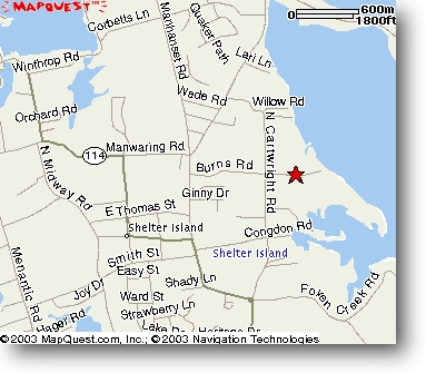
Once on
Shelter Island, follow route 114 South for about 1 ½ miles
to the IGA Supermarket (it is a small market which will be
on your right). As
Route 114 veers to the
right at the Supermarket, you do not follow it,
but rather you go straight ahead onto Manwaring Road.
Continue until you reach a small traffic circle and
turn right onto St. Mary’s Road.
Turn left at the first road, which is Burns Road.
Follow Burns Road past the stop sign (at Cartwright
Road). St.
Gabriel’s is the second driveway on the right as you
approach the water.

Location
and Directions
From
South Ferry:
Sunrise
Highway, Route 27 East.
Follow Route 27 to exit 8 on the left, Sandy Hollow
Road to North Sea Road; turn left at the light.
Follow North Sea Road to Noyack Road; it will bend to
the right. Follow
Noyack Road
until you see the “Waterside Restaurant” on the left.
Turn left after the “Watersisde” onto Long Beach
Road. Follow to
blinking Red Light. Go
straight on Route 114 North and follow signs to North Ferry
and take ferry to Shelter Island.
Once
on Shelter Island, follow Route 114 north to first traffic
circle. At the
circle Route 114 turns left; do not follow 114, instead go
straight onto Cartwright Road.
Follow Cartwright Road about 3/4 of a mile to Burns
Road. Turn right onto Burns Road St. Gabriel’s is the second
driveway on the right as you approach the water.